Judging NYC BigApps
NYC is running an app developer contest in partnership with ChallengePost and Rackspace. It is called NYC Big Apps. I blogged about this back in early October when Mayor Bloomberg announced the competition and noted that I am one of the judges in the contest.
The submittal part of the competition is over and 85 different apps have been submitted. They are all listed here. I am slowly working my way through them. It's quite an effort to look at 85 different apps. Some run on the web. Some run on iPhones. Some run on Android. Some run on SMS.
I thought I'd open this up a bit and let all of you have some say in my judging. If you want to weigh in on my voting, please take a look at the apps and highlight any of them you think merit serious consideration by me in the comments to this post.
However, it is critical that you disclose to me if you have any vested interest in this competition. I don't have any problem with someone leaving a comment that says "my app is called ….., and here's why I think you should vote for it". I do have a big problem with a comment promoting your app if you don't disclose that it is yours.
I am judging these apps on multiple criteria, including usefulness, inventiveness, the visual look and feel, how far it has been commercialized to date, and most importantly in my mind, how much government transparency it provides.
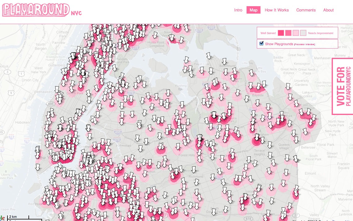
I'll end with a screenshot of one app that I spent time on this morning that I like called Playaround which maps playgrounds by neighborhood. Very nicely done.
Comments (Archived):
You’ve got your hands full.
tell me about it. that’s why i’m asking for some help
I’m kind of surprised that a lot of the NYC apps available via appify,http://appify.com/new-york-…are not on the NYCBigApps list.I guess it’s due to some criteria or another.
NYC Way looks pretty cool, I like that it’s web+mobile and it’s a consolidation of cool data and NYC based apps. Great execution too.
i like that one too
I’m Peter Cetinski, one of the developers of the ParkShark application in the NYC BigApps competition. I would appreciate your honest feedback. Let me know if there are any questions you have. Also, thanks for taking the time to participate in this competition. As a developer, it is quite exciting interacting with other developers who are trying to solve the same problems, each taking a different approach with different technologies. We’re having a lot of fun regardless of who wins!
i’ll make sure to give ParkShark a good look
I’m in the Playaround target demographic: UES resident, two kids between 2 and 5. The map is interesting, but didn’t tell me much I didn’t know about my own neighborhood. (Its value to me is what is in other areas.) But my wife and I have long bemoaned how not all playgrounds are equal — some are really great for kids in our age bracket (e.g. Mariners’ Gate Playground on 86th and CPW, just inside the park) while others are pretty bad (e.g. on the SE corner of 96th and Lex).I replied substantively to them at http://www.playaroundnyc.co… but I think the real issue is that NYC needs to do more than just open the data up. They need to adopt good apps as official ones. My wife’s inclination was to wonder merely if there was a listing of parks with writeups about them, and frankly, outside of Google, we had no way of finding that information. Had NYC lended its pagerank powers to that sort of database, it’d be a lot more powerful.
I’m with you here…back when the contest was first announced I took a peek through the various datasets (which by the way were laughable in many ways — you’re going to run a ‘developer’ challenge and offer up data in excel spreadsheets? really? I guess it’s better than nothing, but only barely)…my biggest problem was that while there some ‘interesting’ data, there really wasn’t enough there for me to think of anything too interesting to spend a lot of cycles developing something with…to me the big problems have been:1. The data is open and available, but pretty disconnected….which means that 99% of what will be built is going to fall into that ‘neat for 5 minutes’ category but probably has very little long-term value/use (sort of like a large percentage of the initial iPhone apps).2. Just being available doesn’t mean it’s ‘easy’ to work with…there’s just too much work involved with the current offerings to do anything useful…which basically means there are very few 1-2 day hackfests people could dump simple things out with that are intended to only be ‘neat for 5 minutes’ (see the catch 22 here?).I’m sure a handful of apps will emerge out of the pile…and that’s cool…but I’m also sure that a large percentage of disgruntled (or at least disappointed) developers are going to emerge out of that pile too…and to me that REALLY hurts this overall idea long term (I wish they had spent a little more time putting together a real API and opening/offering up the data via that)….hopefully I’m wrong though and enough momentum is built with this initial contest that more gets done, more becomes open, and eventually we start to see the true useful apps emerge…
Maybe tiny grants to developers would have been a better approach than the contest. Things get fishy when gov funding supports innovation. Was the effort a no cost effort to the gov/us? Who owns the outputs/products?
I don’t mind them running a contest…and one big payout is cool (and I think good motivation)…I just personally would have liked to see them develop an actual API (even if it meant taking away some of the cash prize to pay for the development of a real API)…I think making it easy for developers to play with the data is almost as important as giving them the data to play with in the first place (especially if you want the apps to survive beyond the initial contest)…
I like that path Kevin.1) lower barrier for developer entry, and all future development with that dataset2) profitIt improves the connectivity of the data with the rest of the web. Right now there are these islands of excel sheets that require some special effort to get a grip on. A more straight forward standard interface would encourage others to write to it, and utilitize as much of the data as they wished.I haven’t spent much time going over the city data, would you be interested in taking a wag at a rough format? I know it’s too late for the competition, but I could help (quick and dirty hack) something along those lines. I may never use it, but someone else sure could. It would have to be a pretty limited effort (I’m tied up on other work for all my main cycles). Maybe talking to some of the contest members would help pull some of the pieces together?
Why do you think I like this one so much: http://www.pushpinweb.com/Has the most potential to develop into a serious API for how cities should display data and what kinds of data they should display. And the choices they gave are well supported.
pushpinweb and actuatr are both doing that
that’s why actuatr is interesting. it doesn’t appeal to me as a contender but it does attempt to solve some of these problems
you can already see that in this comment thread. but is it really surprising that the city’s data is a mess?
It’s great that the city is giving free marketing press to some apps. But why not open the judging to crowd sourced voting on the web, it’s a democracy fail in my opinion.Best of luck to any gov data weilding super startups. My instinct is to stay as far away from government rules, regulations, control as possible. Let the market decide value, not the big beauracracy.Still, that they did anything of the sort shows a shift in the right direction.Good luck with the MASS review Fred, I don’t envy the loss of attention this is going to cost you.
Two of the awards are crowdsourced and frankly, those just boil down to popularity contests. No person in the general public is going to fairly wade through 80+ apps and choose the best. What happened was everyone tweeted out “vote for my app!” and the entire thing broke down in seconds. Crowdsourced voting never works on the web — it’s all about who has more twitter followers.
It is interesting that so many iPhone specific apps are getting such large numbers of votes. Even if the iPhone is the most popular (at 4%) smartphone in the US, 96% of mobile phone users don’t have one.There are even many iPhone apps that have 20-40 votes but are not even available in the app store yet!
Ideally, everyone’s input is valued. We usually vote with our wallet, but we can just as well vote with our attention.I respect that popularity can heavily stack the deck in favor of those with more influence or pull. But if the challenge were prolonged, perhaps for a year and the measure was the usage, engagement, and interoperability of the app, wouldn’t that be a better score than a small focus group of judges?
I like the Rent Sleuth application.
such a great initiative. kudos to the Mayor and NYC for embarking on these kind of projects.the amount of innovation bought about and value created for $20,000 is staggering.respect to all the developers taking part too.social entrepreneurship at its finest
sms apps, markslater has said here that sms is the mobile command line, i think that makes a lot of sense.apps that use the camera, because they are mobile native, albert noted this in his mobile post. i think the camera-based apps are some of the coolest, most promising, and likely to fit into the disruptive paradigm.
Mark is bang on. sms is the lowest common denominator in mobile communication.sms apps have been big in Europe for a long time now, it makes me laugh every time Robert Scoble dismisses sms. You can talk about iphone apps and droid apps all you like (and for sure that is the future) but sms is the here and now and every phone comes “preloaded” with it!
Happy judging Fred! That’s exciting and I’m looking forward to the results. Wishing you a great 2010! -Ryan Singer
Mark, the competition offers multiple prizes one of which is judged by the public.
Thanks Peter. I count on human filters for much of the quality information I consume so why shouldn’t a big crowd of users help us figure out which apps are the best. Preferably through usage statistics (a real measure), as opposed to just clicking on an upvote link they get shared by a friend (Edith described the limited value of the open vote).
The problem with that is you by end up with a kind of “tyranny of the majority”. There are many topics that are for niche audiences (imagine an app for pregnant women, or senior citizens, or school kids, etc, etc), but that are nevertheless exceptionally clever, creative, etc.
Don’t we already suffer this in our current government system… ;)And engagement (timer per user) would be a statistic that could help identify utility per user
I built the NYC BigMaps submission, and am thinking in retrospect that I should have split it up into multiple submissions as a marketing ploy and to garner more popular votes.http://www.nycbigapps.com/a…If you look at just the restaurant data part, it’s got all the data and most or more features that restaurant-specific apps like Soup Fly, NYC Eats, and Eat Clean.ly have, but rolls them all into one site that:- maps every restaurant- provides RSS and KML feeds to keep you informed of changes in your neighborhood- heatmaps by category for the entire city- access to all the data and maps on any mobile browser (not just iPhone users)- an API that lets anyone tap in to the geographic data and detailsThen BigMaps doubles all that by doing the same thing for 311 Service Calls.The depth of all this in not apparent if you just glance around the site for a few seconds, and only manifests when you use it for a bit. I probably should have submitted 8 apps that broke it all down so people could compare apples to apples (so to speak):- Restaurant health review maps, heatmaps, and full details- Restaurant health review iPhone browser application- Restaurant health review mobile browser application- Restaurant health review open API and data feeds- 311 service calls maps, heatmaps, and full details- 311 service calls iPhone browser application- 311 service calls mobile browser application- 311 service calls open API and data feedsThanks and take a look at it in detail to make an accurate comparison!
That’s a good idea (in hindsight) Michael. I see it as a marketing/PR grab for your development projects. Simplifying the first 10-30seconds of a users visit would likely help garner a positive reaction.
i’ll do that
As a developer, I’m a fan of Push Pin Web. I met some of the team at a Meetup for BigApps some time last month. I planned on entering (AR Android App) for a shot at dinner with Bloomberg :). Anyway, they provide a set of APIs for developers to use to easily access the NYC Data.
Man, Bob Moses would love that playground tool. I could see a big use for it in the public planning sector, basically a SimCity for real life planning.
Hi Fred, I developed one of the apps on the list, called UpNext. Please try it out 🙂 One of our big aspirations is to move mapping beyond Google/Mapquest/Microsoft tile-based maps, a format that hasn’t been touched in awhile. Our maps are ‘vector-based’, and animated in real-time; to see the difference this makes, try doing a category search or tapping a building.Our maps are also fully sourced by public data (roads, intersections, buildings, geocoding, parks, lakes, borough boundaries, neighborhoods — all of it). And NYC BigApps gave us access to much, much more. It’s a great development, and we’ve seen our expansion possibilities multiply 5-10x in the last few months as lots of cities jump on and open their data. Good times.
i’ll make sure to check it out
I would like to see an app for ethnic diversity (locations, cultural events, restaurants, etc)Im starting an activity group for my daughter and any other children who want to do a weekly exploration of all the diversity NYC has to offer. Since fatherhood, my eyes have been opened to how much is available to us culturally, and how little of it is used. Our children have the capability to experience almost every ethnic group and language in the world, yet most of us opt for the homogenized group of like minded folks we are around all day. Experience is the best teacher.
A great idea. However it seems that on the ladder of data/visualation >> insight >> action, most apps are still on the data level. The closest that can lead to action is NextTown (but not with data insight).This leaves us with the “everyday helpers”: “ParkShark” and “Daily Spoonful” look useful.
Hey Walkies – Website and iPhone AppHey W., NYCAll the others look interesting. but I like dogs.
Hi all, I’m the developer of the entry Trees Near You (http://treesnearyou.com), an iPhone app for learning about all the sidewalk trees in NYC, from individual tree species/size info, to aggregate environmental effects.There were several motivations for me to make this particular app, some of which were:- “Green” isn’t what comes to mind when people think of NYC. I wanted to help change that perception.- Allows you to learn something about your own block, but also zoom out to the neighborhood or further up to compare to and hopefully reflect on other parts of the city.- Helps people understand how street-level city decisions relate to larger environmental impacts (CO2 offset, etc.).- Provides a low-touch way to make your daily walks a little more interesting and whimsical.- Shows off the scale and density of NYC’s municipal data (about 600,000 trees, in every little corner of the city).- Exposes a data set (street trees) that I hadn’t yet seen anywhere else on the web (contra to, say, restaurant inspection data which is already widely available via Everyblock, etc.).- Makes use of mobile / location-aware capabilities.- Makes use of open source mapping technologies (OpenStreetMap, Mapnik, etc.), to help show off what can be done by going beyond the typical Google map.- Keeps the application data & functionality focused (not a kitchen sink app of data).Other apps in the competition that I like (often for similar reasons as above) include Taxihack, Playaround, Big Apple Ed, and Blocks & Lots.
I’m the developer of Taxihack (and a big fan of Trees Near You, too). I was drawn to the oddness of the dataset, and also wanted to build something where people could interact with the data via Twitter and email.I also like Actuatr, Big Apple Ed, Blocks & Lots, NYC Landmarks.John Borthwick tweeted his feedback as he dug through the submissions, which I thought was interesting: http://twitter.com/JohnBort… (from 12:55 PM Dec 27th on up)
I like your idea. I think the potential is there. Is it in the App Store ?
Hello Fred:My app is called NYC Way (http://www.nycway.com): 30+ Apps in one App Box with Social Media Integration and Resident Reporting – available both as an iPhone app and a web app.1. NYC Way gives you 30+ NYC related apps bundled into one – including live traffic cams, street food vendors, restaurant inspection results, recreation (many categories), wanted convicts with pictures, closest subway locations and alerts, NYC news, NYC events and much more. For the complete list, visit http://www.nycway.com/featu…2. Over 20K people are already using the NYC Way iPhone App.3. Available both as an iPhone app and a web app.4. Location awareness available on the iPhone App gives locals and tourists information sorted by proximity.5. Check in functionality from within the app (similar to FourSquare, Gowalla) using a twitter channel.6. Share on Facebook and via Email using the app.7. Resident reporting available via a twitter channel – Consumer issues, Traffic report, NYC shout out.8. Ranked top 20 (18 today) within top travel apps on iTunes app store – with 80+ 5 star ratings.Happy Judging!
one of my favorites
Our team based at the CUNY Graduate Center developed the OASIS mapping site (Open Accessible Space Information System). You can read a thorough article about OASIS, why it was created, and how it’s being used in the city at UrbanOmnibus (http://urbanomnibus.net/200….In addition to submitting an app, I’ve also blogged about the BigApps competition and the city’s DataMine (http://spatialityblog.com). Thanks for asking for comments about the apps and the process (though I’m not sure my observations will will help with your voting 🙂 ).The competition has brought out an impressive number of apps, and it’s too bad we (and you) can’t vote for more than one. Perhaps next time each category can have a winner, rather than just one or a couple overall. Many of the apps really have such different purposes and use a wide variety of different data sets, that it’s hard to say that one is necessarily better than the other.Also, some of the projects (like ours) aren’t designed or intended for commercialization. So we’ll certainly lose on that category, even though these applications may be well-designed, utilize lots of data in creative ways, and be incredibly helpful for the broad public. At the same time, we’re not a city agency project so we wouldn’t be eligible for the City Talent Award (and actually, one of the “selling” points behind a project like OASIS is that it isn’t a city agency project — it transcends multiple public agencies at all levels of government).Of course, the city doesn’t need a competition to open up access to its data — it should be doing (and should have been doing) that regardless. But it’s impressive to see the number of new people looking at the city’s data sets with an eye toward repurposing them for broader use. At the very least, hopefully that will make the city to realize that people beyond the bureaucrats and agency staff actually want to use the data to improve life in the city. And that will prompt the city to do a much better of making data available.
Hi, (I’m the developer of http://www.playaroundnyc.com)I had a similar feeling about the judging categories. Not all of the apps are designed to be commercialized and will therefore be hamstrung in that area. It’s unfortunate that there are no judging criteria that are focused on community activism. Maybe the city can consider this if they do another contest in the future.Noel
great app. love it.
Thanks!
i spent a fair amount of time on OASIS. it’s an impressive piece of work. i actually vote for all the apps, give them each a score.
Thanks Fred.
Hey Fred. Thanks for giving us all another venue… and a very direct one at that! I helped make Blocks And Lots (http://www.blocksandlots.com).We tried to stay close the to the principals of open government by making an app that:** is available to the widest range of users for the widest range of purposes (iPhone apps are great as a part but not as the whole),** makes the underlying data available thru an API (a non-proprietary and machine readable format).Blocks And Lots offers a widget which showcases how an API can be used directly by an app running right in the browser (the widget is just html and javascript) and that could be extended to Android or iPhone too, and an API which provides the city’s data AND is also writable so that the city’s data can be added to with new content.For example, we’d love to see a feedback loop added to Blocks And Lots (by the city or by any developer) that enables people to report errors in the data to the city (1000s of errors are reported each year generally when someone is trying to refinance or sell and suddenly can’t); we’d love to see consumer-focused location-based apps that help people make even more informed decisions by being able to see the history of a building when standing in a living room with a real estate broker.- Kael GoodmanFrom my blog:http://appfactory.blankslate.com/2009/04/defini….http://appfactory.blankslate.com/2009/05/tim-be…http://appfactory.blankslate.com/2009/05/its-ca…
I like Make My Day NYC. “Curated” itineraries of things is a pretty slick way to get some event recommendations.
Re Playaround: I love the fact that the entire East Village / Lower East Side (my ‘hood) is depicted as 1 big playground. Couldn’t agree more, though i’m pretty sure i’m using very different criteria.
I think what is the most clear from this is that if Gov (not just NYC but ALL GOV) makes all it’s data available – People will build really cool apps around it. Subsequently these new apps will allow lots of number crunching & GEO data that will allow us taxpayers to reap LOTS of inadequacies out of the system. The other point of interest for me is that of the 80+ apps 100% of them are MAP Mashups (was this a requirement)?http://twitter.com/A_F
I am a member of the team that worked on the BigMapple.com. As some people have mentioned here, the data feeds provided by the city were not always reliable. However, in some respects, we found that the constraints of the contest (and the data we were given) further challenged our creativity. Certainly, this was frustrating at times, but it also forced us to examine our site from different perspectives. In the end, I think that the quality of the data did not diminish the quality of our site. And, judging from some of the other great sites that have been submitted, I’d say it didn’t hinder the other teams’ final results either. New Yorkers are known for being resourceful—and I think that the BigApps contest, whether intentionally or not, brought out this quality in everyone who participated.
For full disclosure, I’m an occasional Processing.JS, the Javascript wrap of Processing made for the Canvas element (I have it, it seems to require Dreamweaver, and Dreamweaver scares me. Too much stuff, I like simple, like Textwrangler, I can’t figure it out). However, for those interested, these are open sourced language(s) used by data-visualization, design and art community types.I mention this because I really like PushPin Web. Although there are visualizations available (some of them are terrible, some of them are great), it seems to be that their goal is to have the dataset available for visualizations in the canvas element for anyone to use, and to use powerfully. Although very few people are aware of it, Processing.JS is by far the one of the most powerful tools for that element (Though they still can’t do OpenGPL play by plays like the Original Processing…) And they are doing it by creating other API tools in Ruby, Python and Perl through JSON API to make the data usable. You could bypass the visualizations for whatever you want. The fact is they made a tool that will be accessible to a wide variety of people that will be well supported by Open Source communities.As a project, it has the most potential by far and away. If I can learn Dreamweaver/Processing.JS for the frontend, someone can learn Python backend and they are wrapping the data, that is huge for the city long term (or I could learn Ruby in the backend as well…)
A good API is a terrific feature of any mashup, and it would be nice to see city governments make their own APIs for developers to get at the data and keep it up to date.Take a look at our BigMaps submission to see how we used our own API, which is similar in purpose to PushPin’s, to build it: http://www.NYCBigMaps.com/ We also use our API to run our own site and a few others.Our free API lets programmers request any of our city data across the nation, specify the format (kml, georss, json, xml, csv, html, etc), for use in their own maps (Google, Bing, OpenStreetMap, Yahoo, ), mobile applications, news readers, and websites. We currently maintain a couple million locations across 28 datasets http://www.yourmapper.com/browse with 7 of them being applicable to the New York Area http://www.yourmapper.com/location/NY/new-york including restaurant inspections and 311 service calls.
I did look, you did an excellent job, but I still prefer PushPinWeb. They essentially decided to opensource NYC onto GitHub and when appropriate use the visualization tools from Processing, a massive open source visualization language. It fulfills the spirit of the competitionDevelopers compete to build apps “in keeping with New York City’s drive to become more transparent, accessible, and accountable and an easier place to live, work and play”Because of the way PushPinWeb is does and the choice to drive deep into a variety of open source communities, if the city wants, you can eventually get high school students running projects off of it. (There are high schools using Processing, you can use a dataset to do whatever you want as a high school for say a class) And that, truly, is deserving. This is extremely forward thinking. It doesn’t tell me what I need to know right now, it gives me opportunity to build for a future.
Hey Fred,The biggest win the City can get out of this challenge is feedback from 80+ teams about how to make their data better and more accessible. There’s a community out there that wants to work with the City to provide world-class services for our citizens and keep NYC the best city on earth.After having built an app for the contest (full disclosure: I’m one of the team behind UncoverYourCity), I can tell you five limitations to NYC becoming a platform for citizens to hack:1) Not all data is machine readable2) Not all data is in open source formats3) Lat/longs are missing and some addresses are poorly formed4) Lots of documentation is lacking5) There’s a paucity of data[See a full discussion at my blog]The net result is that we developers end up spending too much time integrating data (or are actually unable to integrate it) rather than developing great apps.If you have a chance to talk to Mayor Bloomberg or any of the folks at the DOITT, please consider passing these comments along. There’s a community out there that wants to work with the City. NYC Big Apps is a great start and hopefully we’ll get more chances to help create NYC.gov as a platform!
If that’s the case then you know where to begin for correcting a lot of city data. I’m pretty sure it is not just a NYC thing.
You raise some great points about the formatting of the raw data in the Data Mine. These are also problems across other cities that have released some of their data (DC, Chicago, San Francisco, etc).When we work with a governments at Your Mapper to import their data and map it, we first convert it from whatever format it’s in (kml, csv, rss, access, sql, shapefiles, etc) to the Open Municipal Geodata Standard format. Some agencies actually convert the data to this standard for us, saving time and effort on our end and cost on their end. This is a format that is both human and machine readable, and standardized, and with lat/lons if available, addressing points 1, 2, 3, and 4 of your complaints. See http://www.omgstandard.comThe other benefit is that once it’s in OMG format, it can be machine processed into any other format like csv, rss, kml, html, xml, etc. We leverage this in our API by allowing programmers to get the data out of our system in the format they prefer to use.If all governments could present their data in something standard like this, then it would do what you suggest: let developers make great apps and not waste time integrating data.
this is great feedback. we will make sure the city gets this feedback. and i’ll take a close look at your app too.
Commenting here instead of today’s post Fred since Disqus is still active. I echo the mobile web posting adventure. About 95% of my posts over the past 4 months are from my iPhone. It was maddening losing entire posts to wifi going in and out while walking (WordPress app would sometimes lose the entire post). Now I write the post on notepad, then copy it over to ensure I don’t lose hours writing.
Hey Fred,My name is Josh and I am the developer of NYCPRO (New York City Parks and Recreation Online – http://www.neocartography.com/nycpro) in the Big Apps competition. I am a city employee, so I am not eligible for most of the prizes. However, you should vote for me to win the city talent award because…. I think I have created an attractive, easy to use, and useful mash up of google maps, flickr, twitter and the NYC parks department website that also uses over 10 city data sets.And, I have a very cool video for the app – http://www.youtube.com/watc…Thanks for writing about this and seeking others feedback. JP
i’m not sure they should have disallowed city employees but i don’t make the rules
I’m a fan of smart park http://www.nycbigapps.com/a…Disclosure: I work with and am friends with the guy that wrote smark park.For people in the burbs that have to travel or visit the city, the application is really useful to find a place to park. Mass transit for many is not the simplest solution and this can be a big help navigating around effectively. It also allows for pre planning of trips as well.I also want to add that though many people say that their products can’t be commercialized, they need to take a step back and look at the following:1. Slick UI2. Quick load times3. Fetching data and coordinating via GPS/telemetry as to locationReplace the data set you can do anything with this. I am really looking forward to seeing what happens when some of these guys get together and start working together.
NYC Broken meters if it was done as an AR app could be the first truly useful AR app on the market. As of now it’s using a map interface. http://www.youtube.com/watc…BigAppleEd created a great simple interface for very focused data that you generally do not get to see.http://www.bigappleed.com/s…Blocks and Lots is great, super simple, very useful, great representation of data.http://blocksandlots.com/wi…and although it’s a bit ambitious, I really like what BldgBeat is trying to do, and their ability to make fairly dull info cool-looking, and interactive..http://vimeo.com/8060024and nexttown actually put pictures in for the reps, making the data look appealing. http://www.nexttown.org/and my winner for packing data into mobile effectively http://nynyx.com/nyxp.aspx
i wish you were judging! nice work and thanks for the help
I am the co founder of Localnext.Localnext was founded with one goal in mind; Help users find NYC events/venues in a fast and efficient way.As the first step to achieve that goal, we put together a map based interface that helps users to find out what is happening in a neighborhood. We also have incorporated some intuitive filters for narrowing down the results based on category, time and neighborhood.We have added some necessary features like, saving an event and sharing an event with your friends and or add it to a calendar of choice. We are now working on adding more features which will be rolled out in the immediate future.Please do checkout our application http://www.localnext.com.Your feedback is highly appreciated.
I count on human filters for much of the quality information I consume so why shouldn’t a big crowd of users help us figure out which apps are the best. Preferably through usage statistics (a real measure), as opposed to just clicking on an upvote link they get shared by a friend (Edith described the limited value of the open vote).